
AQUANAVI: Navigating Grand Challenges and their Mitigation using Aquatic Experimental RIs
Science clusters

Summary
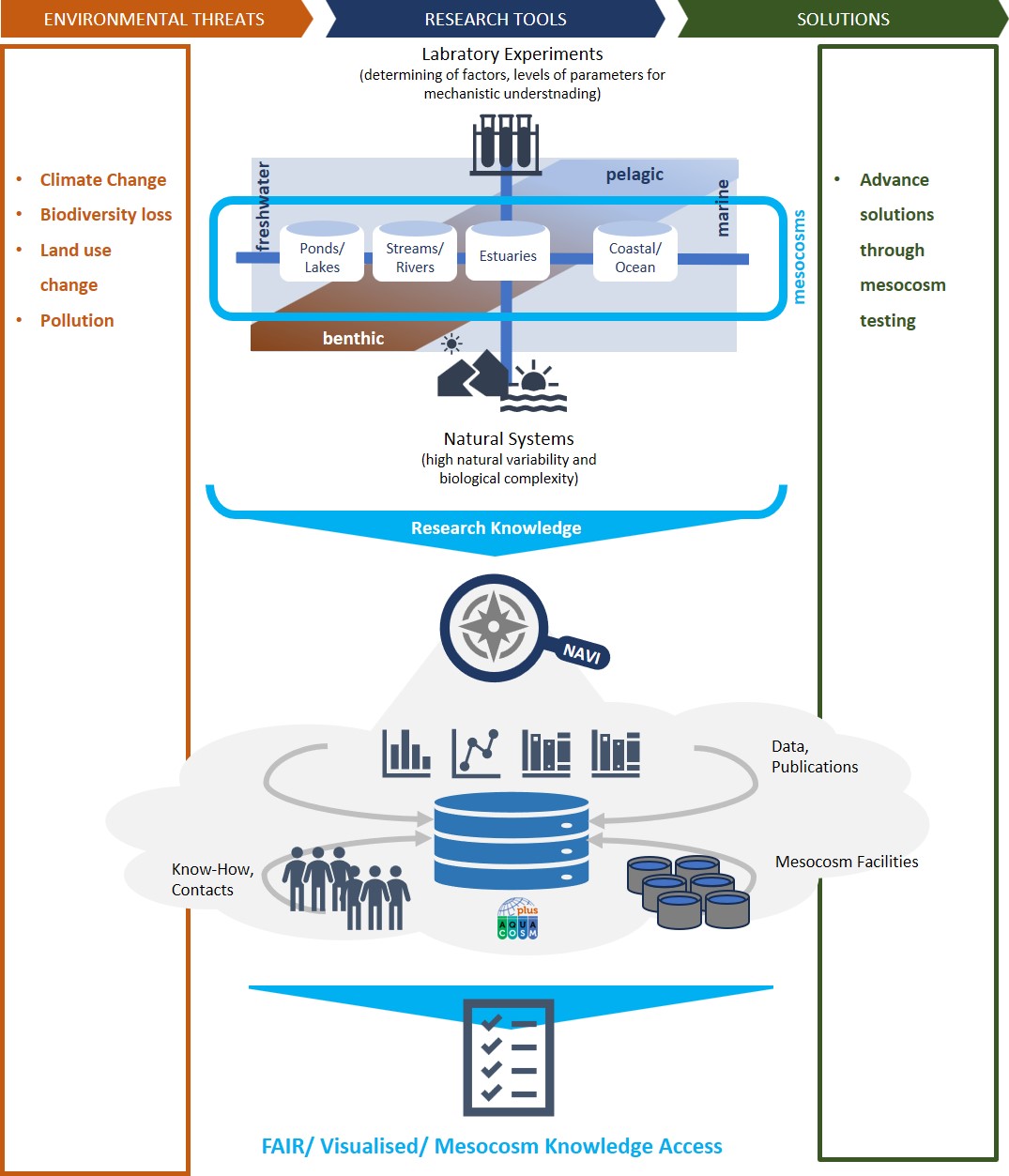
Critical environmental challenges affect aquatic ecosystems worldwide, and the need to coordinate research efforts is increasingly urgent. Mesocosms are key Research Infrastructures (RIs) allowing the study of highly complex environments comparable to natural ecosystems. Mesocosm experiments, which offer controlled yet realistic settings, are crucial for understanding and mitigating the impact of various stressors and their combinations on aquatic ecosystems. The AQUACOSM-RI consortium, comprising over 60 individual state-of-the-art mesocosm facilities at 28 host institutions across Europe, has therefore been instrumental in advancing aquatic environmental research across climate zones including marine, brackish and freshwater ecosystems.
The AQUANAVI project (Navigating Grand Challenges and their Mitigation using Aquatic Experimental RIs) aims to create an interactive atlas of aquatic mesocosm-based experimental research. Data, publications, reports and information generated by the AQUACOSM consortium and other mesocosm facilities worldwide will be integrated into a single, accessible platform incorporating Open Knowledge Maps' AI-driven visual discovery tools. The project will foster collaborations and, by enhancing data FAIRness, it will facilitate fast discovery and efficient use of aquatic RIs globally, accelerating the development of environmental mitigation strategies.
Challenge
Open Science project, Open Science Service, Cross-domain/Cross-RI
Aquatic ecosystems are under pressure from a variety of stressors, including pollution, habitat degradation, rising temperatures, and ocean acidification. These challenges interact in complex ways, making it difficult to predict their combined effects and develop mitigation measures. Experimental mesocosms, which offer controlled but realistic environments, are critical for studying the impact of these stressors. However, despite their significance, the extensive yet fragmented resources available in mesocosm-based research remain difficult to access and leverage.
Solution
AQUANAVI addresses this by creating an interactive atlas that integrates data, publications, reports and facility information from the AQUACOSM consortium and other mesocosm RIs worldwide. This platform enables quick discovery of available resources, facilitating new collaborations and expediting experimental setups. Using the Hi Knowledge platform, AQUANAVI merges advanced semantic capabilities (e.g., Wikidata), AI technology (e.g., Open Knowledge Maps), and visualisation tools (e.g., Open Knowledge Maps and Scholia) to help researchers navigate complex information with ease, using cutting-edge visualisation techniques, artificial intelligence, and knowledge synthesis methods, and bridging gaps between disconnected research facilities and data sources.
Scientific Impact
Open and collaborative by design, AQUANAVI’s architecture will engage a broad range of research communities. By consolidating data and information from diverse RIs, the platform will leverage and enhance the AQUACOSM and related RIs, securing the reusability and interoperability of existing data collections and better exploration of existing RIs in the future.
Compliant with FAIR principles and EOSC requirements, AQUANAVI will ensure the long-term sustainability and openness of its resources, enriching both the ENVRI services portfolio and the broader scientific community. In summary, AQUANAVI will empower researchers and stakeholders to implement measures to mitigate the effects of climate change and other Grand Challenges facing aquatic environments, serving as a key resource within and beyond the European Research Area.
Results
- SPARQL endpoint: the initial queries to uncover metadata in our corpus were produced
- OAI-PMH endpoint: an initial OAI-PMH endpoint was set up, and the functioning of the data pipeline through the data aggregation and visualisation services used in the project has been proven.
- Data modelling started: created a first version of a table with metadata properties on the aquatic mesocosm facilities, experiments conducted and related publications to be represented on the AQUANAVI platform.
- Sample data evaluation: Open Knowledge Maps first conducted a thorough evaluation of the sample data provided by mesocosm.org.
- Main usage scenario and user needs defined for geomap prototype: In order to identify the most important data needed for the tools Open Knowledge Maps wants to build, user needs were analysed, and the project team agreed on the main issues to be solved in this project. A main usage scenario was defined to guide important decisions around metadata and main functionalities.
- Open Knowledge Maps metadata requirements: Based on the main usage scenario and the sample data evaluation, Open Knowledge Maps put together metadata requirements. These are important guidelines for the OAI-PMH endpoint developed in “Task 3 - Semantic data environment”. The document also includes two tables, one for the mapping of document data and one for mapping mesocosm facility data.
- Designs for Geo Map’s main functionalities: Based on the main usage scenario Open Knowledge Maps created a first draft of the designs of the visualisations main functionalities.
- Evaluation of Geo Map libraries: Open source geomap libraries were evaluated by Open Knowledge Maps according to their ability to fulfil user needs, UX and technical requirements. A library has been selected.
- Necessary updates to Open Knowledge Maps technical platform: Open Knowledge Maps has implemented necessary technical upgrades to their platform: a PHP upgrade, as well as significant improvements to application loading times.
- Grant proposal open access in the journal RIO - DOI
- Necessary updates to Open Knowledge Maps technical platform: Open Knowledge Maps has implemented a react upgrade to enable the integration of a new library for the Geo Map visualisation.
Proposal published: the project team published their grant proposal open access in the RIO journal RIO. It is thus the first contribution in our topical collection in that journal. DOI: https://doi.org/10.3897/rio.11.e176476
- Implementation of mesocosm data integration: Open Knowledge Maps implemented a dedicated endpoint for the data from mesocosm.org in their open source visualisation software Headstart. Research into how to represent the mesocosm data in the BASE schema was carried out and the results were added to the metadata recommendations. A mapping and enrichment function was created as well as a Mock API, that returns enriched mesocosm data in the BASE schema.
- First prototype of Geo Map frontend integration: Open Knowledge Maps has developed the first prototype of a geographical discovery tool for mesocoms. For this, they integrated the Leaflet library in their open source visualisation software Headstart. After the library was integrated successfully, the new visualisation type was connected to the mesocosm data. Representing the mesocosm data on the map, handling important edge cases and developing interactions on the map according to design specifications was completed. And finally interactions between the Geo Map and other UI components (e.g. list, search field & filters etc.) were implemented.
- Conceptual classification scheme for ecological grand challenges finalised: Finalisation of the controlled vocabulary for ecological grand challenges that the project team will use to annotate publications and enrich RI metadata. Existing Wikidata identifiers have been re-used as far as possible.
- Data management plan published: https://doi.org/10.5281/zenodo.18879772
- Abstract submitted for the community engagement workshop “How to publish in RIO to make your Aquatic Mesocosm facility more visible” for the ASLO/SIL joint conference
- Controlled vocabularies for Research Topics and Controlled Parameters: the project team finalised a first version of two controlled vocabularies, the first on topics that are addressed in mesocosm-based research, and the second containing terms for describing factors that can be manipulated in mesocosm facilities.
- Data model for semantically describing aquatic mesocosms: finalisation of the data model for representing aquatic mesocosm research infrastructures.
- Classification of mesocosm research publications: the project team used >500 mesocosm research articles listed on aquacosm.eu and mesocosm.org assigned grand ecological challenges, mesocosm facilities, author keywords, and DOIs to each of them, thereby establishing a base for visualisation, comparison and targeted digital search of mesocosm facilities, or e.g. research topics.
- Publications in wikidata: The above mentioned mesocosm research articles have been integrated in WIKIDATA, which represents the technical groundwork to be further used in the visualisation and search functionalities of the AQUANAVI atlas.
- Geo Map deployed for the mesocosm community: Following extensive quality assurance, bug fixing and technical refinements, the OKMaps Geo Map was successfully deployed to the production environment at mesocosm.org/facilities. The deployment was carried out in several stages, allowing project partners to present an initial version to the community before introducing further data updates and new features. The resulting service provides a stable and user-friendly entry point for discovering aquatic mesocosm facilities.
- Mesocosm metadata updated and integrated: The Geo Map was updated with the latest mesocosm information provided by FVB-IGB, including new metadata fields such as Grand Ecological Challenges and refinements to existing metadata. These updates improve the completeness and quality of the information available through the discovery service.
- Geo Map usability and accessibility improved: Numerous refinements were implemented to improve the user experience, including redesigned controls, improved accessibility, enhanced sharing and citation features, informative tooltips, a "More information" panel, and snapshot generation for social media sharing. Additional improvements included new map layers, zoom controls, a more intuitive default world view, and a dedicated /geomap/ URL. Together, these enhancements make the Geo Map easier to use, share and reuse.
- Search interface for Open Knowledge Maps visualisations enhanced: The search and filtering interface used across Open Knowledge Maps visualisations was redesigned to support flexible configurations for different visualisation types. For the Geo Map, the interface was tailored to the available mesocosm metadata by focusing on full-text search while disabling filters that are not applicable to research infrastructures. This provides a simpler and more intuitive discovery experience for users while making the interface reusable for future applications.
- Streamgraph topic quality improved: Generic MeSH terms were removed from the Streamgraph visualisation, improving the quality and interpretability of automatically generated topic labels and providing clearer insights into temporal developments in aquatic mesocosm research.
- Search interface for visual discovery of mesocosm research: Open Knowledge Maps prepared a dedicated search interface for the AQUANAVI repository, enabling users to generate Knowledge Maps and Streamgraphs from publications indexed in the project's repository. The search interface provides easy access to Open Knowledge Maps' visual discovery services and lays the foundation for interactive exploration of the scientific literature associated with aquatic mesocosm research. As the OAI-PMH endpoint becomes fully operational and the repository continues to grow, the resulting visualisations will provide increasingly comprehensive overviews of research topics and their development over time.
Publications
- “Project collection” in the open access journal RIO, including research Ideas and outcomes where documentation will be added over the project’s course | DOI: https://doi.org/10.3897/rio.coll.298
- AQUANAVI: Navigating Grand Challenges and their Mitigation using Aquatic Experimental RIs - https://doi.org/10.3897/rio.11.e176476
- AQUANAVI Data Management Plan: https://doi.org/10.5281/zenodo.18879772
- AQUANAVI Poster - 2nd OSCARS AGM - https://doi.org/10.5281/zenodo.18787215
- Kraker P., Stella A. Berger; Jens C. Nejstgaard; Katharina Makower; Tina Heger, Jonathan M. Jeschke; Christopher Kittel; Daniel Mietchen; Maxi Schramm; Steph Tyszka (2026), AQUANAVI: A New Navigation Tool for Aquatic Mesocosm-Based Research To Address Grand Challenges and Their Mitigation, EGU General Assembly, DOI: http://dx.doi.org/10.5194/egusphere-egu26-14079 - https://doi.org/10.5281/zenodo.20830359
Events
- 17-19 February, 2025 | Vienna, Austria - AQUANAVI Project Kick-Off Meeting
- 26-31 March, 2025 | Charlotte, North Carolina, USA - ASLO 2025 Aquatic Sciences Meeting
- 15-16 October, 2025 | Stechlin, Germany - AQUANAVI Project Meeting
- 17-19 October, 2025 | Stechlin, Germany - WIKI workshop
- 27 January 2026 | Online - Community Engagement Workshop. Meeting with researchers engaged with mesocosm facilities. Goals: Introduction to AQUANAVI; motivation for updating facility information; discussing collaborative ways to publish knowledge about AQUACOSM and other mesocosm facilities and activities; joint work on harmonising terminology.
- 3-8 May 2026 | Vienna, Austria - EGU 2026 - The AQUANAVi project was presented by P. Kraker, P.. titled: “AQUANAVI: A New Navigation Tool for Aquatic Mesocosm-Based Research To Address Grand Challenges and Their Mitigation”, with focus on the Geo Maps functionality.
- 12-16 May 2026 | Montreal, Canada - ASLO-SIL 2026 Joint Meeting - The AQUANAVi project was presented by S.A. Berger, S. A. with a talk titled: “AQUANAVI: A New Navigation Tool for Aquatic Mesocosm-Based Research To Address Grand Challenges and Their Mitigation" to international aquatic scientists in the special session (SS082 Mesocosm-based approaches for tackling grand challenges in aquatic ecosystems), organised by the AQUACOSM ECR network. The AQUANAVI team also organisd an in-person workshop with 10 participants to introduce and promote the updated RIO template and informed participants on how to use it to create publications that describe their mesocosm facilities incl. Discussion and feedback from the participants (WS15 How to publish in RIO to make your Aquatic Mesocosm facility more visible).
- September 2026 | Berlin, Germany - DGL conference
Other promotional material
- POSTER | Open Scholarly Metadata for Sharing the Nuances of Research Processes. Workshop on Open Citations 2025 (WOOC 2035), Bologna. Zenodo.
Principal investigator
Tina Heger (Dr.) is an ecologist by training, with a focus on conceptual theory, invasive species, novel ecosystems and ecological novelty. She is engaged in cross-disciplinary research including data scientists and philosophers with the aim to enhance knowledge synthesis and knowledge representation in ecology. She joined the Leibniz Institute of Freshwater Ecology and Inland Fisheries (IGB) in Berlin, Germany, as a PI in 2021. Currently, she is leading a research group at the Center for Interdisciplinary Studies (ZiF) in Bielefeld, Germany, on “Mapping Evidence to Theory in Ecology”.
- AQUANAVI Infographics
- Project web page on IGB website
- AQUANAVI Newsletter