Science cluster & challenges

Summary
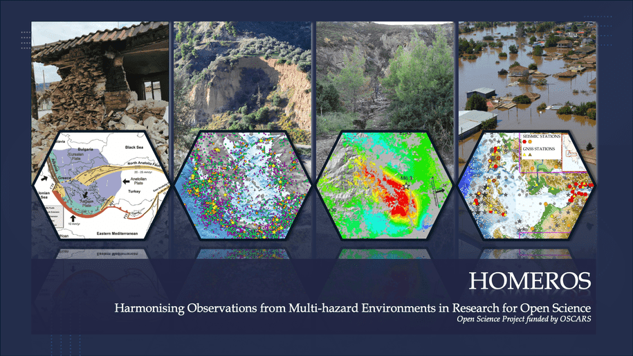
In today's interconnected world, communities face a diverse range of hazards, including natural disasters like earthquakes, floods, and landslides, as well as human-induced events. To address these challenges, the HOMEROS project aims to strengthen multi-hazard assessment methodologies in seismology, geodesy, and geology. Leveraging technical solutions suited to the big data era, HOMEROS represents a significant advancement in standardising research processes, promoting collaboration, and enhancing understanding and prediction capabilities for natural hazards through Open Science practices. Focusing on high-risk areas in Greece with significant seismic activity, strong earthquakes, floods, and landslides, HOMEROS will compile earthquake catalogues and assess ground deformation products to provide a comprehensive evaluation of seismic hazards. Additionally, it will enhance the understanding of flood and landslide risks, vital for effective mitigation strategies.
Challenge
Open Science project, Cross-domain/Cross-RI
Communities worldwide face a wide range of natural and human-induced hazards, which require more robust, data-driven approaches to assessment and mitigation. In regions like Greece, where seismic activity, floods, and landslides pose significant threats, existing observation systems often lack standardisation when combining interoperable services from diverse resources related to essential geohazard variables, hindering effective multi-hazard assessments. The HOMEROS project addresses these issues by developing methodologies that harmonise data and services, aiming for a more unified and comprehensive hazard assessment strategy.
Solution
The project integrates interoperable services from various sources, including pan-European data services (within the ENVRI Science Cluster), local resources (at the national level), and the EOSC, to standardise research processes. By comparing two geographical areas in Greece as case studies, each representing multi-hazard environments, HOMEROS aims to identify network and data needs crucial for improving earth observation and hazard assessment capabilities. Integration with the ENVRI Community and the EOSC will enable HOMEROS to utilise Open Science environments effectively, facilitating multidisciplinary data exchangeability and showcasing the value of integrating e-science tools in research. Moreover, the project will address data challenges, develop scientific workflows, and provide open access datasets and products essential for comprehensive multi-hazard assessments, including seismic data, ground deformation data, and information on landslides and floods.
Scientific Impact
HOMEROS will establish links between institutions, research infrastructures (RIs) and projects to disseminate results and promote the use of RI services for scientific purposes. Through the promotion of Open Science practices, it aims to democratise access to knowledge, encourage multi-disciplinary collaboration, and enhance community resilience against interconnected hazards. By offering accessible ecosystems for data exchange following the FAIR principles, HOMEROS will advance scientific knowledge in multi-hazard assessment. Its approach, characterised by transparent data sharing, collaborative modelling, and active community engagement, aims to catalyse significant changes in disaster preparedness, response strategies, and recovery processes. Ultimately, the project will empower communities worldwide to build resilience and adapt to the ever-changing risk landscape. Such open and collaborative efforts can lead a global shift towards more resilient societies.
Results
- Use Case Demonstration: Seismological Data Processing Workflows in VREs within EU Node - In this use case, the project team tested how the early release of the EOSC EU Node can support everyday workflows in natural hazard research. They developed and ran Jupyter Notebooks to retrieve and analyse seismological data from open databases. For earthquakes in particular, it was demonstrated automated detection and analysis of seismic signals using open data and machine learning tools. A demonstration of statistical quality control on datasets commonly used in seismicity studies was conducted, offering insight into basic performance indicators—such as the time savings achieved when research workflows are executed on cloud-based VREs compared to local execution. Through these tests, the scalability and flexibility of the EOSC platform were explored, aiming to support data-driven research and improve tools for hazard assessment. All use cases were first demonstrated during the EOSC Symposium (watch the video) in October 2024, and later in webinars organised by the Swedish Research Council (January 2025) and the Hungarian Open Science Forum (April 2025).
- Creation of a Zenodo Repository for Workflow Sharing and Reproducibility
- Installation of Permanent GNSS Stations on Lefkada and Kefalonia for Enhanced Seismic Monitoring: As part of the HOMEROS project’s mission to improve multi-hazard assessment in seismically active regions of Greece, two permanent GNSS stations were successfully installed on the islands of Lefkada and Kefalonia. Equipped with high-rate Trimble receivers and collocated with existing seismographs, these stations provide continuous, high-resolution ground deformation data. Integrated into the national seismological and Hermes GNSS networks, they support advanced seismic hazard modeling and earthquake cataloguing. Committed to FAIR and Open Science principles, the data are planned to be openly accessible, fostering collaboration and enhancing risk mitigation efforts. | PICTURES
- Establishment of Collaboration with Greek Association of Academic Libraries to develop Data Management Template for Geosciences: Members of HOMEROS have become early adopters of new tools and services developed by the libraries, such as institutional repositories, DOI services, and the Data Management Plan (DMP) tool. In collaboration with library experts, they will make a first attempt in autumn 2025 to create a shared DMP template tailored to the needs of Geosciences. This will mark an important milestone for advancing research practices in the field across Greece.
- Preparation and Adoption of Data Management Plans: HOMEROS research groups continuously review and implement FAIR and Open Science data management practices, ensuring open access to project data and metadata, supporting reproducible workflows. Building on the newly established collaboration with the Greek academic library community, HOMEROS partners are now preparing coherent project-wide Data Management Plans using the HEAL-LINK DMP tool, refined to address geospatial, seismological, and geodetic data requirements. This work lays the foundation for the upcoming integration of a dedicated Geosciences DMP template, supporting interoperable, well-documented, and reusable research outputs.
- Continuous uploading and sharing of project data/research outputs to HOMEROS Zenodo Repository: As part of the project’s Open Science and FAIR data strategy, HOMEROS research teams have already uploaded project documents (9, including conference papers, technical notes and posters), datasets and research outputs (9) to the dedicated HOMEROS Zenodo community repository. The repository will continue to be expanded throughout the project lifetime.
- Continuous Uploading and Open Sharing of GNSS Geodetic Data: HOMEROS supports the continuous uploading and open sharing of geodetic data from its permanent GNSS station through a Hardmin-supported repository. By systematically archiving project data in a trusted research data infrastructure, HOMEROS promotes FAIR and Open Science practices, enabling transparent access, long-term preservation, and reuse of geodetic observations by the wider scientific community.
- Extensive Mid-Term Technical Report: The HOMEROS project successfully compiled its mid-term technical report, documenting progress achieved to date across scientific activities, data management, and Open Science implementation. The report provides a consolidated overview of the research performed within HOMEROS, the project milestones, key results, and future directions, ensuring transparency and accountability within the OSCARS framework. The report has been shared with the ENVRI-Hub, aiming to provide (scientific and RDM-related) content to their Knowledge Base.
Publications
- Conference paper | The 2025 seismicity burst in the Santorini – Amorgos seismovolcanic zone, DOI
- Conference paper | Cultivating FAIR principles for multi-hazard assessment, DOI
- Conference paper | Fostering FAIR approaches to the seismological data life cycle, DOI
- Conference paper | HOMEROS project for natural hazards: An example from northern Peloponnese, Greece, DOI
- Conference paper | Continuous GNSS Geodetic Networks. A Powerful Tool for Monitoring and Understanding Complex Volcanic Environments: The Case of Santorini Volcano During the Seismic Crisis of 2024-2025, DOI
- Conference paper | Ground Deformation in Nisyros Volcano (Greece) Determined by GPS and SAR Interferometric Techniques, DOI
- Technical note | New Permanent GPS stations installation of HOMEROS Project, DOI
- Dataset | Western Gulf of Corinth & Central Ionian Islands Seismic Hazard Dataset, DOI
- Dataset | Western Gulf of Corinth – Seismic Benchmark Dataset (WGoC-SBD), DOI
- Dataset | Ground Deformation Dataset for Geohazard Monitoring in the Central Ionian Islands (Greece) within the HOMEROS Project, DOI
- Dataset | January - April 2024 Ionian islands Swarm-like excitation relocated earthquake catalog, DOI
- Dataset | Geospatial Datasets and Hazard Assessment of Flood and Landslide Events in the Northern Peloponnese, Greece, DOI
- Dataset | Flood events and flood hazard zone in Ionian Islands and Western Greece, DOI
- Dataset | 2025 Santorini–Amorgos NLL-SSST-coherence high-precision relocated earthquake catalog, DOI
- Dataset | 2024 Central Ionian Islands earthquake dataset, DOI
- Dataset | Machine-Learning derived, NLL-SSST-coherence high-precision relocated earthquake catalog for the 2025 Santorini–Amorgos seismic crisis, DOI
Events
- 23 October, 2024 | Online - EOSC Symposium 2025
- 19 November, 2024 | Lund, Sweden - LU Open Science Days 2024
- 27 January, 2025 | Online - EOSC and EU Node Webinar
- 3 April, 2025 | Online - Hungary Open Science Forum-EOSC EU Node Webinar
- 28-31 May, 2025 | Mytilene, Greece - 17th International Congress of the Geological Society of Greece
- 2-6 June, 2025 | Santander, Spain - EGI2025
- 31 August - 5 September, 2025 | Lisbon, Portugal - The HOMEROS project itself and its potential outcomes, including multi-hazard dynamics, supporting the development of improved forecasting models and mitigation strategies in central Ionian Islands and the western Gulf of Corinth (Greece) was presented through a poster presentation at IAGA IASPEI 2025. Additionally, the HOMEROS seismic hazard data collection for the Western Gulf of Corinth and the Central Ionian Islands, was presented via another poster presentation.
Other material
- POSTER | Harmonising Observations from Multi-hazard Environments in Research for Open Science. Expectations and first examples from the EOSC EU Node services for Researchers, LU Open Science Days 2024, 19 November 2024, Lund, Sweden.
- POSTER | Cultivating FAIR principles for multi-hazard assessment, 17th International Congress of the Geological Society of Greece.
- POSTER | Fostering FAIR approaches to the seismological data life cycle, 17th International Congress of the Geological Society of Greece.
- POSTER | HOMEROS project for natural hazards: An example from northern Peloponnese, Greece, 17th International Congress of the Geological Society of Greece
- PRESENTATION | HOMEROS – Harmonising Observations from Multi-hazard Environments in Research for Open Science, 1stOSCARS Annual General Meeting, Rome, Italy.
- PRESENTATION | FAIR Data Management in Academic Research: Leveraging Digital Infrastructure for Open Science, EGI2025, 2-6 June 2025, Santander, Spain.
- PICTURES
- POSTER | Enhancing Multi–Hazard Assessment with the HOMEROS project in central Ionian Islands and the western Gulf of Corinth
- POSTER | The OSCARS seismic hazard data products for the Western Gulf of Corinth and the Central Ionian Islands, Greece
Other resources
The HOMEROS repository on Zenodo is used as a central channel for the communication, dissemination, and open sharing of project outputs. To date, the repository hosts 9 datasets, which represent the primary research outputs of the project, complemented by additional dissemination and technical materials, including 6 conference papers, 1 technical note, 3 posters, and 2 presentations. The repository is continuously expanded with project workflows, datasets, and scientific results, ensuring open access, long-term preservation, and enhanced visibility of the project outcomes within the scientific community and the wider public, in line with Open Science and FAIR principles.
Principal investigator
Eleftheria E. Papadimitriou is a geologist and seismologist with a deep commitment to advancing the field of geophysics. With a Bachelor's degree in Geology and a Ph.D. in Seismology, her career is dedicated to furthering our understanding of earthquake generation. She has fostered international collaborations and established connections with 55 foreign institutions and actively participated in more than 65 research projects, assuming scientific responsibility for 20 of them. With over 240 publications and 2500 citations, her research has made a lasting impact on the field of geophysics.
- HOMEROS Infographics
- HOMEROS repository on Zenodo